South Africa's Professional 3D Laser Scanning & Scan-to-BIM Specialists
Delivering high-accuracy 3D laser scanning, point cloud surveys, digital twins, and as-built building documentation for architects, engineers, contractors, property owners, insurers, developers, and real estate professionals throughout South Africa.
Powered by LiDAR technology, BIM3D Scanning Services captures existing buildings and environments with exceptional accuracy, transforming real-world spaces into intelligent digital assets. Our reality capture solutions include Matterport virtual tours, point cloud data, Scan-to-BIM workflows, CAD-ready documentation, and detailed as-built surveys.
Matterport Pro3
LiDAR Technology
Revit & CAD
Ready Deliverables
Point Cloud
Documentation
Nationwide South
African Service
Industries We Serve
Reality Capture Solutions for Every Industry
BIM3D Scanning Services provides professional 3D laser scanning, Matterport digital twins, point cloud surveys, Scan-to-BIM, and as-built documentation tailored to the unique requirements of every industry.
Projects
3D Laser Scanning & Reality Capture Projects
Explore a selection of completed 3D laser scanning projects delivered across commercial, industrial, heritage, residential, and retail sectors throughout South Africa.
Services
Professional 3D Laser Scanning & Digital Building Services
From reality capture and point cloud surveys to Scan-to-BIM, digital twins, and as-built documentation, BIM3D Scanning Services delivers accurate digital building solutions across South Africa.
Industrial Facility Scanning
Accurately scan factories, warehouses, and industrial plants supporting maintenance, retrofit planning, equipment documentation, and long-term asset management.

Technology
Why LiDAR Technology
BIM3D Scanning Services uses Matterport Pro3 LiDAR technology to deliver professional 3D laser scanning, digital twins, point cloud data, and Scan-to-BIM solutions with exceptional speed, accuracy, and reliability across South Africa.
LiDAR Precision
Capture existing buildings with ±20mm accuracy using advanced LiDAR and photogrammetry, creating reliable point cloud data and digital building documentation.
BIM-Ready Workflows
Export registered point clouds directly into Revit, AutoCAD, Archicad, and BIM software for accurate modelling, design, and coordination.
Faster Documentation
Reduce site visits and deliver digital building documentation faster than traditional surveying methods, accelerating projects from capture to completion.
±20mm
Scanning Accuracy
80%
Faster Documentation
1000x
More Data Points
50%
Cost Reduction
Reduced Site Visits
Access accurate digital twins remotely, enabling inspections, measurements, stakeholder collaboration, and project reviews without repeated site visits.
Remote Collaboration
Share interactive Matterport digital twins with architects, engineers, contractors, and clients for faster decisions and seamless project collaboration.
Digital Twin Advantage
Create intelligent digital building records supporting renovations, maintenance, facility management, insurance documentation, and long-term asset lifecycle planning.
Deliverables
Professional Deliverables
Receive industry-standard point cloud, BIM, CAD, and digital documentation deliverables compatible with leading architecture, engineering, construction, and facility management workflows.
Point Cloud Data
.e57 / .rcp / .rcs
Registered point cloud data for BIM, CAD, and engineering workflows.
Revit Models
.rvt
Accurate Revit models for design, coordination, and renovations.
CAD Drawings
.dwg / .dxf
Precise CAD drawings from laser scanning for accurate building documentation.
Floor Plans
.pdf / .dwg
Floor plans supporting renovations, leasing, and facility management projects.
Elevations & Sections
.pdf / .dwg
Detailed elevations and sections for planning, design, and construction documentation.
Matterport Digital Twins
Web / App
Digital twins enabling remote walkthroughs, inspections, and collaboration anywhere
4K Still Images
.jpg / .png
High-resolution imagery for documentation, marketing, and insurance.
PDF Documentation Reports
Comprehensive documentation reports for compliance and project records.
Existing Conditions Docs
Multi-format
Complete existing conditions documentation for renovation and planning.
Services Areas
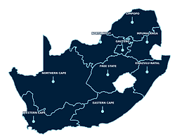
Nationwide Coverage
Providing nationwide reality capture, digital building documentation, and Scan-to-BIM solutions for commercial, industrial, residential, and heritage projects.
Gauteng
Johannesburg • Sandton • Pretoria • Centurion • Midrand • and More
[26.2041° S, 28.0473° E]
Western Cape
Cape Town • Stellenbosch • Somerset West • Paarl • George • and More
[33.9249° S, 18.4241° E]
KwaZulu-Natal
Durban • Umhlanga • Pietermaritzburg • Richards Bay • Ballito • and More
[29.8587° S, 31.0218° E]
Eastern Cape
Gqeberha • East London • Mthatha • Jeffreys Bay • Graaff-Reinet • and More
[33.9608° S, 25.6022° E]
Free State
Bloemfontein • Welkom • Sasolburg • Bethlehem • Kroonstad • and More
[29.0852° S, 26.1596° E]
Mpumalanga
Mbombela • Witbank • Middelburg • Secunda • White River • and More
[25.4753° S, 30.9699° E]
Limpopo
Polokwane • Tzaneen • Mokopane • Lephalale • Musina • and More
[23.9045° S, 29.4689° E]
North West
Rustenburg • Mahikeng • Klerksdorp • Potchefstroom • Brits • and More
[25.8652° S, 25.6442° E]
Northern Cape
Kimberley • Upington • Kathu • Kuruman • Springbok • and More
[28.7282° S, 24.7499° E]
Get Started
Ready to Digitally Capture Your Project?
Planning a renovation, construction project, insurance assessment, or existing conditions survey? Contact BIM3D Scanning Services for professional 3D laser scanning, Matterport digital twins, Scan-to-BIM, and point cloud documentation anywhere in South Africa.
Contact
Get in Touch
Contact BIM3D Scanning Services for professional 3D laser scanning, Matterport digital twins, Scan-to-BIM, point cloud surveys, and as-built documentation anywhere in South Africa.


Service Areas
-
Western Cape
-
Eastern Cape
-
Northern Cape
-
Free State
-
Gauteng
-
Kwazulu-Natal
-
Limpopo
-
Mpumalanga
-
North West